Elevate Your Online Presence: Aerial Photography at Custy Law’s New Office. Valparaiso, IN
On March 20th, 2026, Custy Law Firm, LLC proudly welcomes clients to its new office in Valparaiso, Indiana. Marking an exciting new chapter of […]
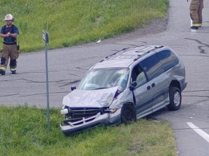
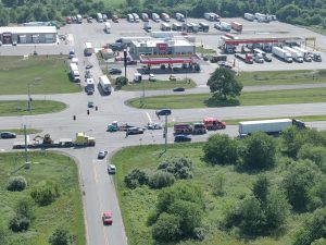 Accident Reconstruction:
US 30 East of Wanatah, IN 7/7/2025
Accident reconstruction relies heavily on precise visual documentation to determine the sequence of events that led to a crash. Traditional ground-based photography provides only a limited perspective, often obscuring critical details such as distances, traffic flow, and surrounding conditions. Aerial photography, on the other hand, delivers a complete top-down view of the accident scene, allowing investigators to capture every detail from a clear and unobstructed angle.

Using drone technology equipped with high-resolution cameras, aerial imagery can accurately record vehicle positions, skid marks, fluid trails, debris patterns, and the relationship of these elements to fixed landmarks such as intersections, signage, and guardrails. This bird’s-eye perspective allows for precise mapping and measurements that can later be used to create 3D models, diagrams, and visual reconstructions for court presentations, insurance evaluations, or engineering studies.
Modern aerial systems used by Falcon Vision DSP are capable of remarkable image clarity. Our equipment can read a vehicle license plate from over 800 feet away, proving the accuracy and quality of the imaging system. This level of precision ensures that no critical details are missed — whether it’s identifying a vehicle, reading roadway signage, or documenting tire tracks that may fade quickly after an incident.
 Another major advantage of aerial photography is speed and safety. Accident scenes can be documented quickly from above without interfering with ongoing emergency or cleanup operations. This reduces the risk for personnel on the ground and minimizes disruption to traffic flow. Additionally, because aerial images can cover a large area in a single flight, they eliminate the need for multiple ground shots and reduce the potential for missed evidence.
Aerial documentation also provides time-stamped, GPS-verified imagery, giving investigators and legal professionals confidence in the authenticity and accuracy of the data. When combined with photogrammetry software, these images can be transformed into highly detailed maps and elevation models that assist in determining impact points, vehicle trajectories, and visibility lines.
On March 20th, 2026, Custy Law Firm, LLC proudly welcomes clients to its new office in Valparaiso, Indiana. Marking an exciting new chapter of […]