Elevate Your Online Presence: Aerial Photography at Custy Law’s New Office. Valparaiso, IN
On March 20th, 2026, Custy Law Firm, LLC proudly welcomes clients to its new office in Valparaiso, Indiana. Marking an exciting new chapter of […]
October 28, 2025; Property Easement Dispute.
The Right Shot at the Right Altitude: Aerial Photography Over Big Barbee Lake, Warsaw, Indiana
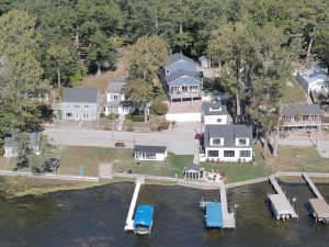
On October 28, 2025, at 8:30 AM, Falcon Vision DSP conducted a series of aerial photography missions over the north shore of Big Barbee Lake, located in Kosciusko County, just outside Warsaw, Indiana.
The purpose of the flight was to support an ongoing property easement dispute, focusing on documenting shoreline boundaries, seawall placement, and existing structures. The objective was to obtain clear, measurable imagery that could be used to help resolve questions of property lines and riparian rights.
 Combining Drone Precision and Aerial Coverage:
To ensure both accuracy and perspective, Falcon Vision DSP employed a dual approach. Using drone technology, we captured low-altitude, high-resolution images that clearly showed the shoreline features and property boundaries in detail. Drones provide precise positioning and maneuverability, making them ideal for close-range inspection and documentation work.
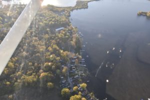
In addition to the drone imagery, a local private pilot assisted in capturing high-altitude photos from a fixed-wing aircraft. These wider shots provided valuable contextual information, allowing property owners and surveyors to compare the immediate shoreline with its surroundings and larger environmental layout.
Why Altitude Matters:
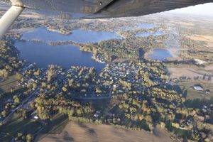 Each aerial platform serves a unique purpose. Helicopters and fixed-wing aircraft excel at wide, landscape-scale imager perfect for capturing a full lakefront or development area in one frame. However, these traditional methods often come with higher operational costs and more logistical planning.
Drones, by contrast, can be deployed quickly and affordably. They can fly lower, closer to the target, and produce centimeter-level accuracy, ideal for surveying, inspections, mapping, and documentation.
Cost-Effective Solutions for Property Documentation:
At Falcon Vision DSP, we bridge the gap between precision and perspective. For most property documentation projects, our drones provide the most cost-effective and detailed imagery available. But when a broader, regional view is needed — such as verifying encroachments, visualizing lot boundaries, or assessing waterfront layouts — we collaborate with trusted local pilots to provide manned aerial photography as well.
 This combined capability allows us to tailor each project to the client’s needs — delivering accurate, court-ready visual evidence while keeping costs under control.
Serving Kosciusko County and Beyond:
Based in Valparaiso, IN , Falcon Vision DSP provides aerial photography, mapping, and inspection services throughout Northern Indiana and Southern Michigan . From property disputes and construction documentation to roof inspections and environmental monitoring, we offer professional-grade imagery that helps clients make informed decisions with confidence.
For more information or to schedule an aerial photography session, contact Falcon Vision DSP — where the right altitude always brings the right perspective.
This is an Up Date to my 10/05/2025 Blog.
On March 20th, 2026, Custy Law Firm, LLC proudly welcomes clients to its new office in Valparaiso, Indiana. Marking an exciting new chapter of […]