Elevate Your Online Presence: Aerial Photography at Custy Law’s New Office. Valparaiso, IN
On March 20th, 2026, Custy Law Firm, LLC proudly welcomes clients to its new office in Valparaiso, Indiana. Marking an exciting new chapter of […]
Protecting Shorelines: How Drones and Infrared Imaging Improve Seawall Inspections
10/03/2025 10:00 am, North Webster, IN
Seawalls play a critical role in protecting lake and coastal properties, but their exposure to constant wave action, tides, and weather can cause hidden deterioration over time. Traditional inspections often require divers, boats, or heavy equipment, making them costly, time-consuming, and sometimes limited in scope. This is where drone technology has become a game changer.
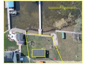 Aerial drones equipped with high-resolution cameras can quickly survey long stretches of seawall, capturing detailed imagery from multiple angles. These images allow engineers and property owners to spot visible issues such as cracks, settlement, or erosion. Even more powerful is the use of drones equipped with infrared (thermal) sensors. Infrared imaging detects temperature variations, which can reveal hidden problems like water infiltration, voids behind the wall, or early signs of sinkholes forming near the structure.
By combining aerial surveys with infrared data, inspections can cover large areas efficiently and with greater accuracy than traditional methods. This proactive approach not only reduces inspection costs but also helps identify deterioration before it becomes a serious safety concern. For coastal communities and property managers, drone-based seawall inspections are quickly becoming an essential tool in preserving shoreline infrastructure.
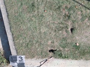
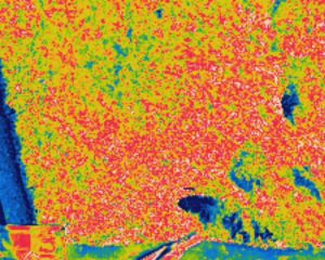
In then first photo you can clearly see the two sinkholes where someone stepped through, along with the infrared scan that highlights the extent of the voids. The dark areas in the IR photo indicate the size of the sinkholes, which formed as a result of erosion.”
On March 20th, 2026, Custy Law Firm, LLC proudly welcomes clients to its new office in Valparaiso, Indiana. Marking an exciting new chapter of […]